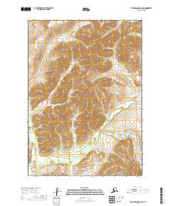
2019 Map of Russian Mission A-3 SE
USGS Topo · Published 2019About this map
The Tuluksak River winds through the southwestern corner of this interior Alaskan landscape, a region defined by a dense network of watercourses and elevation changes. Numerous drainages such as Bear Cr, Shamrock Cr, and the long reach of California Cr carve through the terrain, suggesting a complex watershed north of the river's main stem. Smaller features like Happy Gulch and Tiny Gulch are noted near the intersections of major township boundaries, including t11n r60w and t12n r59w. The map's detail focuses on the natural hydrology and topography of the Bethel Census Area, illustrating the many tributaries that feed into larger regional river systems.
Find a feature on this map
16 named features on this map. Tap any name to fly to it.
Don’t see what you’re looking for? This feature index may not catch every label — zoom into the map to look around manually.
Map Details
Editions of this 2019 Russian Mission A-3 SE Map
This is the sole edition of this map. No revisions or reprints were ever made.
Other maps of this area

1947 · Russian Mission
USGS Topo · 1:250,000

1950 · Russian Mission
USGS Topo · 1:250,000

1950 · Bethel
USGS Topo · 1:250,000

1954 · Russian Mission A-3
USGS Topo · 1:63,360

1954 · Bethel D-3
USGS Topo · 1:63,360

1979 · Bethel D-2
USGS Topo · 1:63,360

1979 · Russian Mission A-2
USGS Topo · 1:63,360

1980 · Russian Mission
USGS Topo · 1:250,000

1980 · Bethel
USGS Topo · 1:250,000
2019 · Bethel D-3 NE
USGS Topo · 1:25,000