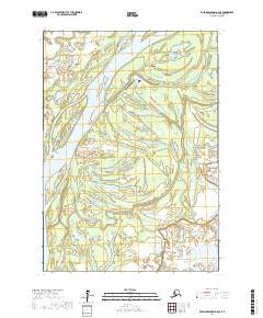
2017 Map of Russian Mission A-6 SE
USGS Topo · Published 2017About this map
Tuluksak sits at the vital junction of the Tuluksak River and the braided Kuskokwim River, serving as a primary point of settlement in this river-delta landscape. This 2017 study illustrates the complex network of sloughs and wetlands that define the terrain of the Bethel Census Area. The infrastructure of the community is anchored by the Tuluksak Airport, which provides essential connectivity for this remote region where transport is heavily dependent on river routes and air travel. The topography is dominated by low-lying floodplains, with the shifting channels of the Kuskokwim showing a dynamic aquatic environment that has long dictated the patterns of human habitation and seasonal movement in this part of Alaska.
Find a feature on this map
8 named features on this map. Tap any name to fly to it.
Don’t see what you’re looking for? This feature index may not catch every label — zoom into the map to look around manually.
Map Details
Editions of this 2017 Russian Mission A-6 SE Map
This is the sole edition of this map. No revisions or reprints were ever made.
Other maps of this area

1947 · Russian Mission
USGS Topo · 1:250,000

1950 · Russian Mission
USGS Topo · 1:250,000

1950 · Bethel
USGS Topo · 1:250,000

1954 · Russian Mission A-6
USGS Topo · 1:63,360

1954 · Russian Mission A-5
USGS Topo · 1:63,360

1954 · Bethel D-6
USGS Topo · 1:63,360

1954 · Bethel D-5
USGS Topo · 1:63,360

1980 · Russian Mission
USGS Topo · 1:250,000

1980 · Bethel
USGS Topo · 1:250,000
2017 · Russian Mission A-6 SW
USGS Topo · 1:25,000