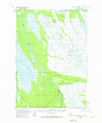
1952 Map of Russian Mission B-1
USGS Topo · Published 1976About this map
The Aniak River meanders through a labyrinth of wetlands and low-lying topography in this early 1950s survey of the Alaska interior. The landscape is defined by the shifting course of the river and its many oxbow lakes, illustrating the natural hydrological patterns before significant modern development. A prominent Winter Trail cuts across the western portion of the terrain, providing a critical land-based transit corridor through the marshy lowlands when the ground and waterways are frozen. Further east, the Buckstock River feeds into the main drainage system, while Swift Creek flows through the southwestern reaches. The map reflects a period when seasonal trails were as vital as the rivers for movement across the Kuskokwim region, captured here through photogrammetric methods from 1951 and 1952 aerial surveys.
Find a feature on this map
5 named features on this map. Tap any name to fly to it.
Don’t see what you’re looking for? This feature index may not catch every label — zoom into the map to look around manually.
Map Details
Editions of this 1952 Russian Mission B-1 Map
2 editions found
Other maps of this area

1947 · Russian Mission
USGS Topo · 1:250,000

1950 · Russian Mission
USGS Topo · 1:250,000

1950 · Sleetmute
USGS Topo · 1:250,000

1952 · Russian Mission C-1
USGS Topo · 1:63,360

1952 · Russian Mission C-2
USGS Topo · 1:63,360

1952 · Russian Mission B-2
USGS Topo · 1:63,360
1952 · Russian Mission B-1
USGS Topo · 1:63,360
1954 · Sleetmute C-8
USGS Topo · 1:63,360

1954 · Sleetmute
USGS Topo · 1:250,000
1954 · Sleetmute A-8
USGS Topo · 1:63,360