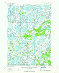
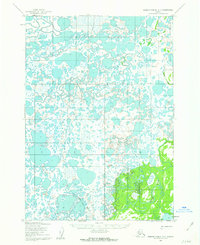
1952 Map of Russian Mission B-6
USGS Topo · Published 1962About this map
Phillips stands as the lone named settlement on this 1952 topographic study of the western Alaskan tundra. The landscape is a complex mosaic of thousands of unnamed lakes and ponds, structured primarily by the wandering course of the Johnson River in the northwest and the Gweek River winding through the southeast. This region reflects a period when seasonal movement was essential for navigation, as evidenced by the Winter Trail cutting through the marshy terrain. These paths were vital for communication and transport before more permanent infrastructure reached this corner of the Yukon-Kuskokwim Delta. Surveyors established local control points like Vabm 34 and Vabm 68 to map this labyrinth of water and land, providing a rare record of the area's hydrology and sparse human footprint during the early 1950s.
Find a feature on this map
6 named features on this map. Tap any name to fly to it.
Don’t see what you’re looking for? This feature index may not catch every label — zoom into the map to look around manually.
Map Details
Editions of this 1952 Russian Mission B-6 Map
This is the sole edition of this map. No revisions or reprints were ever made.
Other maps of this area

1947 · Russian Mission
USGS Topo · 1:250,000

1950 · Russian Mission
USGS Topo · 1:250,000
1952 · Russian Mission C-7
USGS Topo · 1:63,360

1952 · Russian Mission C-5
USGS Topo · 1:63,360
1952 · Russian Mission B-7
USGS Topo · 1:63,360
1952 · Russian Mission C-6
USGS Topo · 1:63,360

1954 · Russian Mission B-5
USGS Topo · 1:63,360

1954 · Russian Mission A-6
USGS Topo · 1:63,360

1954 · Russian Mission A-5
USGS Topo · 1:63,360
1954 · Russian Mission A-7
USGS Topo · 1:63,360