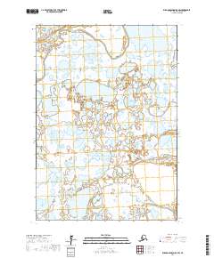
2017 Map of Russian Mission B-8 SW
USGS Topo · Published 2017About this map
Johnson River meanders through the northern reaches of this wetland landscape, part of the extensive river systems that define the geography of the Yukon-Kuskokwim Delta region. The terrain is characterized by a dense network of lakes and ponds, demonstrating the intricate hydrology of the Alaskan tundra. To the south, the Kuichavak River cuts through the lowlands, providing another vital waterway in an area where the water defines the movement of both the landscape and its people. This survey maps a remote portion of the Bethel Census Area where the natural drainage patterns of the rivers and the vast expanse of unnamed lakes remain the dominant features, showing the region as it existed before any significant modern road infrastructure or permanent settlements were established in these specific townships.
Find a feature on this map
8 named features on this map. Tap any name to fly to it.
Don’t see what you’re looking for? This feature index may not catch every label — zoom into the map to look around manually.
Map Details
Editions of this 2017 Russian Mission B-8 SW Map
This is the sole edition of this map. No revisions or reprints were ever made.
Other maps of this area

1947 · Russian Mission
USGS Topo · 1:250,000

1950 · Russian Mission
USGS Topo · 1:250,000

1951 · Marshall
USGS Topo · 1:250,000

1952 · Russian Mission B-8
USGS Topo · 1:63,360

1954 · Russian Mission A-8
USGS Topo · 1:63,360

1954 · Marshall A-1
USGS Topo · 1:63,360
1954 · Marshall B-1
USGS Topo · 1:63,360

1954 · Marshall
USGS Topo · 1:250,000

1980 · Russian Mission
USGS Topo · 1:250,000
2017 · Russian Mission B-8 NE
USGS Topo · 1:25,000