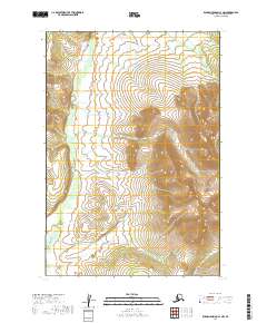
2019 Map of Russian Mission C-1 NW
USGS Topo · Published 2019About this map
The Owhat River dominates the western portion of this Alaskan landscape, carving a wide valley through the interior of the Bethel Census Area. The river's meandering course is set against a backdrop of complex wetlands and rising elevations to the east, where the terrain shifts toward more defined drainages. In the southeast corner, Mission Cr flows through the landscape near the deeply etched Ptarmigan Gulch, illustrating the transition from saturated lowlands to the more varied relief of the interior. This 2019 survey, based on SPOT imagery and data from the National Hydrography Dataset, provides a clear view of the hydrological patterns and natural corridors that define this part of the Russian Mission quadrangle, offering a snapshot of the region's wilderness character before more recent environmental shifts.
Find a feature on this map
7 named features on this map. Tap any name to fly to it.
Don’t see what you’re looking for? This feature index may not catch every label — zoom into the map to look around manually.
Map Details
Editions of this 2019 Russian Mission C-1 NW Map
This is the sole edition of this map. No revisions or reprints were ever made.
Other maps of this area

1947 · Russian Mission
USGS Topo · 1:250,000

1950 · Russian Mission
USGS Topo · 1:250,000

1952 · Russian Mission D-2
USGS Topo · 1:63,360

1952 · Russian Mission C-1
USGS Topo · 1:63,360

1952 · Russian Mission D-1
USGS Topo · 1:63,360

1952 · Russian Mission C-2
USGS Topo · 1:63,360

1980 · Russian Mission
USGS Topo · 1:250,000
2019 · Russian Mission C-2 SE
USGS Topo · 1:25,000
2019 · Russian Mission D-2 SE
USGS Topo · 1:25,000
2019 · Russian Mission C-1 SE
USGS Topo · 1:25,000