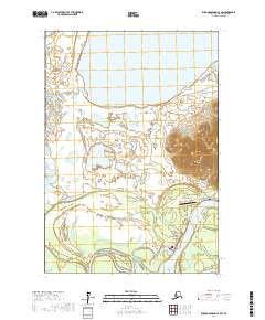
2017 Map of Russian Mission C-4 SW
USGS Topo · Published 2017About this map
Upper Kalskag and Lower Kalskag sit along the winding banks of the Kuskokwim River, serving as the primary human outposts in this landscape of water and tundra. This 2017 survey shows the infrastructure connecting these communities, including Kalskag Road and Airport Road, which leads to the Kalskag Airport. The terrain is defined by a dense network of hydrologic features, from the large expanse of Arhymot Lake and Kukaklik Lake to the meandering paths of Mud Creek and Crooked Cr. The presence of Quarry Road suggests local resource extraction, while the transition between the river lowlands and the higher elevations to the east is documented through clear contouring. Researchers can trace the relationship between these riverine settlements and the surrounding Portage Lakes, reflecting the remote logistics of the Bethel Census Area.
Find a feature on this map
21 named features on this map. Tap any name to fly to it.
Don’t see what you’re looking for? This feature index may not catch every label — zoom into the map to look around manually.
Map Details
Editions of this 2017 Russian Mission C-4 SW Map
This is the sole edition of this map. No revisions or reprints were ever made.
Other maps of this area

1947 · Russian Mission
USGS Topo · 1:250,000

1950 · Russian Mission
USGS Topo · 1:250,000

1952 · Russian Mission C-5
USGS Topo · 1:63,360

1954 · Russian Mission B-5
USGS Topo · 1:63,360

1954 · Russian Mission C-4
USGS Topo · 1:63,360

1954 · Russian Mission B-4
USGS Topo · 1:63,360

1980 · Russian Mission
USGS Topo · 1:250,000
2017 · Russian Mission C-5 SE
USGS Topo · 1:25,000
2017 · Russian Mission C-5 NE
USGS Topo · 1:25,000
2017 · Russian Mission B-4 NE
USGS Topo · 1:25,000