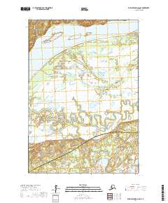
2017 Map of Russian Mission C-8 SE
USGS Topo · Published 2017About this map
The Yukon River dominates this landscape, its wide course cutting through the northern portion of the region and creating distinctive riverine features. Elsie Island sits within the massive waterway, while the prominent Serpentine Bluff rises along the western bank, offering a rare point of elevation in a landscape otherwise defined by intricate wetlands. The interior of the sheet is a complex network of seasonal water bodies and marshes, illustrating the saturated terrain typical of the delta region.
Find a feature on this map
10 named features on this map. Tap any name to fly to it.
Don’t see what you’re looking for? This feature index may not catch every label — zoom into the map to look around manually.
Map Details
Editions of this 2017 Russian Mission C-8 SE Map
This is the sole edition of this map. No revisions or reprints were ever made.
Other maps of this area

1947 · Russian Mission
USGS Topo · 1:250,000

1950 · Russian Mission
USGS Topo · 1:250,000

1952 · Russian Mission C-8
USGS Topo · 1:63,360
1952 · Russian Mission C-7
USGS Topo · 1:63,360
1952 · Russian Mission B-7
USGS Topo · 1:63,360

1952 · Russian Mission B-8
USGS Topo · 1:63,360

1980 · Russian Mission
USGS Topo · 1:250,000
2017 · Russian Mission C-7 NW
USGS Topo · 1:25,000
2017 · Russian Mission B-8 NE
USGS Topo · 1:25,000
2017 · Russian Mission C-8 NW
USGS Topo · 1:25,000