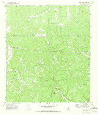
1970 Map of Rust Ranch
USGS Topo · Published 1973About this map
Rust Ranch and Spiller Ranch serve as primary anchors for this ranching landscape along the Menard Co Kimble Co line. Surveyed at the turn of the 1970s, the terrain is defined by a dense network of intermittent drainage patterns including Sheen Draw and West Las Moras Creek, which carve through the Edwards Plateau. The presence of numerous Gravel Pits scattered across the uplands suggests a history of local resource extraction used for road building in this isolated portion of the Texas Hill Country. To the south, Bear Creek and West Bear Creek converge near a permanent Spring, indicating vital water sources for livestock in an otherwise arid environment. A major corridor of Pipelines cuts east-west across the central portion of the map, marking the modern industrial layer superimposed on traditional grazing lands.
Find a feature on this map
13 named features on this map. Tap any name to fly to it.
Don’t see what you’re looking for? This feature index may not catch every label — zoom into the map to look around manually.
Map Details
Editions of this 1970 Rust Ranch Map
2 editions found
Other maps of this area

1893 · Fort McKavett
USGS Topo · 1:125,000

1954 · Llano
USGS Topo · 1:250,000

1954 · Sonora
USGS Topo · 1:250,000

1955 · Llano
USGS Topo · 1:250,000

1956 · Llano
USGS Topo · 1:250,000

1958 · Sonora
USGS Topo · 1:250,000

1963 · McKegan Draw
USGS Topo · 1:24,000

1963 · McKegan Draw NE
USGS Topo · 1:24,000

1970 · San Augustine Draw
USGS Topo · 1:24,000

1970 · Julio Draw
USGS Topo · 1:24,000