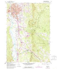
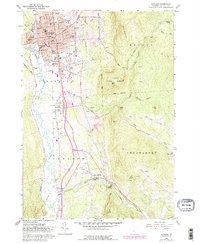
1961 Map of Rutland
USGS Topo · Published 1988About this map
The urban core of Rutland serves as the focal point of this 1961 survey, revealing a landscape where civic institutions and industrial infrastructure meet the Green Mountains. The map highlights the city's role as a regional hub, featuring the Courthouse, City Hall, and numerous parochial and public schools like Mount St Joseph Academy and Longfellow Sch. Industrial activity is evident along the Clarendon and Pittsford RR, which follows the path of Otter Creek. South of the city, the landscape transitions into the agricultural and rural character of Clarendon, where the Rutland State Airport and the Gravel Pit near the Mill River reflect local economic needs. Notable recreation and preservation areas include Pine Hill Park and the expansive Aitken State Forest, which contains sections of the Appalachian Long Trail winding through the high elevations of East Mountain.
Find a feature on this map
64 named features on this map. Tap any name to fly to it.
Don’t see what you’re looking for? This feature index may not catch every label — zoom into the map to look around manually.
Map Details
Editions of this 1961 Rutland Map
5 editions found
Other maps of this area

1891 · Rutland
USGS Topo · 1:62,500

1893 · Wallingford
USGS Topo · 1:62,500

1893 · Rutland
USGS Topo · 1:62,500

1894 · Pawlet
USGS Topo · 1:62,500

1895 · Castleton
USGS Topo · 1:62,500

1897 · Pawlet
USGS Topo · 1:62,500

1897 · Castleton
USGS Topo · 1:62,500

1903 · Mettawee
USGS Topo · 1:125,000

1944 · Proctor
USGS Topo · 1:31,680
1946 · Proctor
USGS Topo · 1:31,680