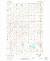
1958 Map of Rutland
USGS Topo · Published 1990About this map
The prairie landscape of Sargent Co comes into sharp focus during the late 1950s, centered on the village of Rutland. This agrarian region is defined by a dense network of seasonal wetlands and glacial lakes, including Silver Lake and Sprague Lake, which drain toward the Wild Rice River in the south. The settlement pattern is anchored by the crossing of the Great Northern Railroad and the Minneapolis St Paul and Sault Ste Marie, illustrating the critical role of rail transport in the transport of grain and cattle from the local plains.
Find a feature on this map
21 named features on this map. Tap any name to fly to it.
Don’t see what you’re looking for? This feature index may not catch every label — zoom into the map to look around manually.
Map Details
Editions of this 1958 Rutland Map
2 editions found
Other maps of this area

1907 · Wyndmere
USGS Topo · 1:125,000

1953 · Kidder
USGS Topo · 1:24,000

1953 · Milbank
USGS Topo · 1:250,000

1953 · Fargo
USGS Topo · 1:250,000

1956 · Fargo
USGS Topo · 1:250,000

1956 · Havana
USGS Topo · 1:24,000

1958 · Milbank
USGS Topo · 1:250,000

1958 · Marlow
USGS Topo · 1:24,000

1958 · Rutland
USGS Topo · 1:24,000
1958 · Forman
USGS Topo · 1:24,000