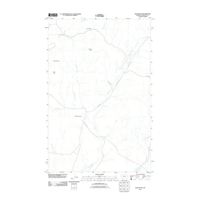
2011 Map of Ryan Butte
USGS Topo · Published 2011About this map
Ryan Butte and McNamara Butte anchor this high-plains landscape in Chouteau County, where the terrain is defined by dramatic elevations and an intricate system of drainages. The map reveals a remote network of ranch roads and historic paths, most notably the Cow Island Trl, which winds past Eagle Creek in the central portion of the quadrangle. This area represents a classic Montana rangeland configuration, where water sources like Frenchman Creek, Little Eagle Creek, and Little Sandy Creek dictate the placement of local infrastructure. To the north, Salt Coulee and Godfrey Creek cut through the terrain near the Flying A Butte, illustrating the geological transition between high buttes and the deep coulees that characterize the regional watershed. The sparse human footprint is marked primarily by named thoroughfares such as Warrick Rd and Beaver Creek Rd, which connect these isolated landmarks across the plains.
Find a feature on this map
17 named features on this map. Tap any name to fly to it.
Don’t see what you’re looking for? This feature index may not catch every label — zoom into the map to look around manually.
Map Details
Editions of this 2011 Ryan Butte Map
This is the sole edition of this map. No revisions or reprints were ever made.
Other maps of this area

1953 · Havre
USGS Topo · 1:250,000

1954 · Lewistown
USGS Topo · 1:250,000

1957 · Havre
USGS Topo · 1:250,000

1958 · Havre
USGS Topo · 1:250,000

1959 · Lewistown
USGS Topo · 1:250,000
1959 · Warrick
USGS Topo · 1:62,500
1959 · Centennial Mountain
USGS Topo · 1:62,500
1984 · Bowery Peak
USGS Topo · 1:24,000
1984 · Centennial Mountain
USGS Topo · 1:24,000
1984 · Seifort Reservoir
USGS Topo · 1:24,000