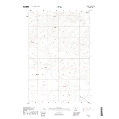
2020 Map of Ryan Butte
USGS Topo · Published 2020About this map
The southern fringes of the Bears Paw Mountains define this section of Chouteau County, where the landscape is marked by prominent high points and a network of named drainages. Notable elevations including Ryan Butte, Flying A Butte, and Mt Hancock rise above the surrounding terrain, providing significant landmarks for navigation. The drainage pattern is complex, with Eagle Creek and its tributary Little Eagle Creek carving through the northern sections, while Little Sandy Creek and Sheep Coulee define the central and southern reaches.
Find a feature on this map
20 named features on this map. Tap any name to fly to it.
Don’t see what you’re looking for? This feature index may not catch every label — zoom into the map to look around manually.
Map Details
Editions of this 2020 Ryan Butte Map
This is the sole edition of this map. No revisions or reprints were ever made.
Other maps of this area

1953 · Havre
USGS Topo · 1:250,000

1954 · Lewistown
USGS Topo · 1:250,000

1957 · Havre
USGS Topo · 1:250,000

1958 · Havre
USGS Topo · 1:250,000

1959 · Lewistown
USGS Topo · 1:250,000
1959 · Warrick
USGS Topo · 1:62,500
1959 · Centennial Mountain
USGS Topo · 1:62,500
1984 · Bowery Peak
USGS Topo · 1:24,000
1984 · Centennial Mountain
USGS Topo · 1:24,000
1984 · Seifort Reservoir
USGS Topo · 1:24,000