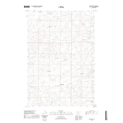
2020 Map of Ryan Creek
USGS Topo · Published 2020About this map
Sourdough serves as a focal point for this section of Sweet Grass County, where the high plains landscape is defined by a dense network of coulees and intermittent drainages. The Glass-Lindsay-Lakes Lower Reservoir in the north captures runoff in an area characterized by seasonal water flow through features like Tangen Draw and Nash Gulch. The map illustrates a rural Montana landscape shaped by local ranching and water management, with the terrain falling away towards Sweet Grass Creek and Ryan Cr. Connectivity across these sections is maintained by local thoroughfares such as Rapelje Rd and Sourdough Rd, which follow the contours of the land between Hamilton Cr and the southern Gunnerson Draw.
Find a feature on this map
19 named features on this map. Tap any name to fly to it.
Don’t see what you’re looking for? This feature index may not catch every label — zoom into the map to look around manually.
Map Details
Editions of this 2020 Ryan Creek Map
This is the sole edition of this map. No revisions or reprints were ever made.
Other maps of this area

1889 · Big Snowy Mountain
USGS Topo · 1:250,000

1891 · Big Timber
USGS Topo · 1:125,000

1893 · Big Snowy Mountain
USGS Topo · 1:250,000

1893 · Big Timber
USGS Topo · 1:125,000

1954 · Big Timber
USGS Topo · 1:24,000
1954 · Otter Creek School
USGS Topo · 1:24,000
1954 · Ryan Creek
USGS Topo · 1:24,000

1954 · Billings
USGS Topo · 1:250,000

1954 · Roundup
USGS Topo · 1:250,000

1955 · Greycliff
USGS Topo · 1:24,000