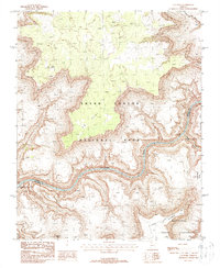
1988 Map of S B Point
USGS Topo · Published 1988About this map
Grand Canyon National Park dominates this terrain, where the Colorado River carves a deep path through the canyon floor. The landscape is defined by massive formations such as Sinyella Mesa and Yumtheska Mesa, which rise sharply above the river's edge. This provisional data from the 1980s captures the hydrological complexity of the area, featuring the convergence of Havasu Creek with the main river at Havasu Rapids. The map also delineates the northern boundary of the Havasupai Indian Reservation, providing a clear record of land jurisdiction near Pocket Point and Yumtheska Point. Distinctive landmarks like Hades Knoll and the narrow formation known as The Cork offer specific points of reference for navigating the vertical scale of this geological corridor.
Find a feature on this map
17 named features on this map. Tap any name to fly to it.
Don’t see what you’re looking for? This feature index may not catch every label — zoom into the map to look around manually.
Map Details
Editions of this 1988 S B Point Map
2 editions found
Other maps of this area

1886 · Kaibab
USGS Topo · 1:250,000

1953 · Grand Canyon
USGS Topo · 1:250,000

1957 · Grand Canyon
USGS Topo · 1:250,000

1958 · Grand Canyon
USGS Topo · 1:250,000

1960 · Grand Canyon
USGS Topo · 1:250,000

1962 · Kanab Point
USGS Topo · 1:62,500

1962 · Tuckup Canyon
USGS Topo · 1:62,500

1962 · Supai
USGS Topo · 1:62,500

1962 · National Canyon
USGS Topo · 1:62,500

1984 · Grand Canyon
USGS Topo · 1:100,000