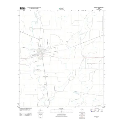
2013 Map of Sabinal
USGS Topo · Published 2013About this map
Sabinal serves as the central hub of this Uvalde County landscape, where the street grid is organized around the intersection of N Front Ave, S Front Ave, and El Paso St. The town's historical geography is deeply tied to its water sources and burial grounds, with the Sabinal River winding along the western edge while several creeks including Elm Cr and Rancheros Cr drain the surrounding ranchlands. Genealogists and local historians can locate three distinct burial sites: Davenport Cem to the northeast, and the Saint Patrick Cem and Sabinal Cem closer to the town center. The transportation network is defined by a mix of residential streets like Polk Ave and rural routes such as Ranch Road 187 and Midway Rd, which connect the town to the outlying Texas brush country.
Find a feature on this map
46 named features on this map. Tap any name to fly to it.
Don’t see what you’re looking for? This feature index may not catch every label — zoom into the map to look around manually.
Map Details
Editions of this 2013 Sabinal Map
This is the sole edition of this map. No revisions or reprints were ever made.
Other maps of this area

1898 · Uvalde
USGS Topo · 1:125,000

1899 · Uvalde
USGS Topo · 1:125,000

1928 · Frio Town
USGS Topo · 1:62,500

1954 · San Antonio
USGS Topo · 1:250,000

1956 · Sabinal
USGS Topo · 1:62,500

1957 · San Antonio
USGS Topo · 1:250,000

1969 · Sabinal NE
USGS Topo · 1:24,000

1969 · Comanche Waterhole
USGS Topo · 1:24,000
1969 · Trio
USGS Topo · 1:24,000
1970 · Irishman Hill
USGS Topo · 1:24,000