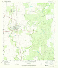
1970 Map of Sabinal
USGS Topo · Published 1973About this map
The city of Sabinal serves as a vital hub in western Texas, situated at the confluence of the Southern Pacific railroad and regional roadways. This 1970 survey illustrates a community deeply connected to its rural roots, featuring a prominent High Sch, the local Rodeo Ground, and essential infrastructure like the Gaging Sta along the Sabinal River. The landscape is defined by the winding paths of Elm Creek and Rancheros Creek, which cut through the agricultural surroundings of the Uvalde and Medina county line.
Find a feature on this map
18 named features on this map. Tap any name to fly to it.
Don’t see what you’re looking for? This feature index may not catch every label — zoom into the map to look around manually.
Map Details
Editions of this 1970 Sabinal Map
This is the sole edition of this map. No revisions or reprints were ever made.
Other maps of this area

1898 · Uvalde
USGS Topo · 1:125,000

1899 · Uvalde
USGS Topo · 1:125,000

1928 · Frio Town
USGS Topo · 1:62,500

1954 · San Antonio
USGS Topo · 1:250,000

1956 · Sabinal
USGS Topo · 1:62,500

1957 · San Antonio
USGS Topo · 1:250,000

1969 · Sabinal NE
USGS Topo · 1:24,000

1969 · Comanche Waterhole
USGS Topo · 1:24,000
1969 · Trio
USGS Topo · 1:24,000
1970 · Irishman Hill
USGS Topo · 1:24,000