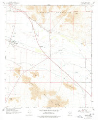
1966 Map of Sacaton
USGS Topo · Published 1978About this map
Sacaton and its surrounding desert landscapes are the focal point of this mid-1960s survey, illustrating the complex irrigation systems of the Gila River Indian Reservation. The map captures a high degree of local detail in the settlement of Sacaton, including the Pima Central Sch, Sacaton Cem, and the Sacaton Radio Tower. Traces of earlier transportation networks appear as the Old RR Grade and Old Railroad Grade cutting across the desert floor toward Olberg.
Find a feature on this map
35 named features on this map. Tap any name to fly to it.
Don’t see what you’re looking for? This feature index may not catch every label — zoom into the map to look around manually.
Map Details
Editions of this 1966 Sacaton Map
3 editions found
Other maps of this area

1907 · Sacaton
USGS Topo · 1:62,500

1914 · Gila Butte
USGS Topo · 1:62,500

1917 · Gila Butte
USGS Topo · 1:62,500

1922 · Casa Grande
USGS Topo · 1:62,500

1922 · Signal Peak
USGS Topo · 1:62,500

1924 · Signal Peak
USGS Topo · 1:62,500

1924 · Casa Grande
USGS Topo · 1:62,500

1952 · Gila Butte SE
USGS Topo · 1:24,000

1952 · Gila Butte
USGS Topo · 1:24,000

1952 · Gila Butte
USGS Topo · 1:62,500