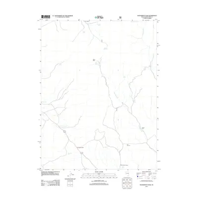
2012 Map of Sacramento Pass
USGS Topo · Published 2012About this map
Sacramento Pass serves as a critical high-elevation transit point through the northern Snake Range, where the landscape is defined by the ephemeral flow of Miller Basin Wash and Black Horse Canyon. This 2012 survey documents a rugged environment where water management is paramount, evidenced by a dense network of high-country water sources such as Reservoir Basin Spring, Chokecherry Spring, and Sacramento Springs.
Find a feature on this map
27 named features on this map. Tap any name to fly to it.
Don’t see what you’re looking for? This feature index may not catch every label — zoom into the map to look around manually.
Map Details
Editions of this 2012 Sacramento Pass Map
This is the sole edition of this map. No revisions or reprints were ever made.
Other maps of this area

1956 · Ely
USGS Topo · 1:250,000

1959 · Ely
USGS Topo · 1:250,000

1959 · Sacramento Pass
USGS Topo · 1:62,500

1963 · Ely
USGS Topo · 1:250,000
1986 · Mount Moriah
USGS Topo · 1:24,000
1986 · Yelland Dry Lake
USGS Topo · 1:24,000
1986 · Sixmile Canyon
USGS Topo · 1:24,000
1986 · Lehman Caves
USGS Topo · 1:24,000
1986 · Old Mans Canyon
USGS Topo · 1:24,000
1986 · South Bastian Spring
USGS Topo · 1:24,000