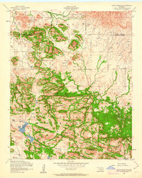
1956 Map of Saddle Mountain
USGS Topo · Published 1963About this map
The Saddle Mountain Indian Mission stands at the northern edge of this mid-century survey, a focal point of cultural history situated near Mountain Creek. To the south, the landscape is defined by the managed conservation lands of the Wichita Mountains Wildlife Refuge, where high points like Pearl Mountain and North Mountain overlook deep cuts such as Moose Canyon. This era shows a rugged terrain peppered with numerous windmills, indicating the vital importance of water management for local ranching and livestock on the plains surrounding the peaks.
Find a feature on this map
36 named features on this map. Tap any name to fly to it.
Don’t see what you’re looking for? This feature index may not catch every label — zoom into the map to look around manually.
Map Details
Editions of this 1956 Saddle Mountain Map
3 editions found
Other maps of this area

1937 · Cache
USGS Topo · 1:48,000

1937 · Quanah Mountain
USGS Topo · 1:24,000

1942 · Cache
USGS Topo · 1:62,500

1949 · Mount Scott
USGS Topo · 1:24,000

1949 · Cooperton
USGS Topo · 1:62,500

1949 · Quanah Mountain
USGS Topo · 1:24,000

1950 · Snyder
USGS Topo · 1:62,500

1950 · Saddle Mountain
USGS Topo · 1:62,500

1955 · Lawton
USGS Topo · 1:250,000

1956 · Saddle Mountain
USGS Topo · 1:24,000