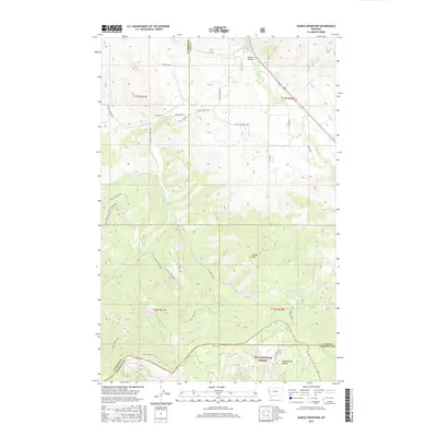
2017 Map of Saddle Mountain
USGS Topo · Published 2017About this map
Jocko Valley serves as a prominent geographic corridor in this western Montana landscape, where the Jocko River and Spring Cr converge. The terrain is defined by significant elevation changes, rising from the valley floor toward the heights of Saddle Mtn and the southern reaches of the Reservation Divide. A complex network of drainage systems, including the N Fork Valley Cr and E Fork Valley Cr, carves through the timbered slopes of the Lolo National Forest. This 2017 survey documents the rural road infrastructure that services the region, notably Old Dixon Rd and Schall Rd, which trace the low-lying areas near the river. The map also delineates the meeting point of three counties—Sanders, Lake, and Missoula—providing a clear view of how political boundaries follow the natural topography of the mountain ridges.
Find a feature on this map
27 named features on this map. Tap any name to fly to it.
Don’t see what you’re looking for? This feature index may not catch every label — zoom into the map to look around manually.
Map Details
Editions of this 2017 Saddle Mountain Map
This is the sole edition of this map. No revisions or reprints were ever made.
Other maps of this area

1956 · Wallace
USGS Topo · 1:250,000

1959 · Alberton
USGS Topo · 1:62,500

1959 · Arlee
USGS Topo · 1:62,500

1960 · Wallace
USGS Topo · 1:250,000

1964 · Dixon
USGS Topo · 1:24,000

1964 · Saint Ignatius
USGS Topo · 1:24,000

1964 · Ravalli
USGS Topo · 1:24,000
1984 · Arlee
USGS Topo · 1:24,000
1984 · Evaro
USGS Topo · 1:24,000
1984 · Huson
USGS Topo · 1:24,000