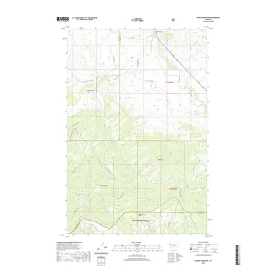
2020 Map of Saddle Mountain
USGS Topo · Published 2020About this map
Lolo National Forest encompasses the southern portion of this Missoula County landscape, where the terrain rises toward the Reservation Divide and the prominent peak of Saddle Mtn. The northern reaches are defined by the broad Jocko Valley, through which the Jocko River flows toward the northwest. A complex network of forest and county roads, including Saddle Mountain Rd and Mill Creek Rd, provides access into the steep drainage basins of the Valley Cr and its tributaries. The map documents the boundary between Missoula, Lake, and Sanders counties, marking a high-elevation topographical transition where named waterways like Hewolf Cr and Burnt Point Cr carve through the national forest lands.
Find a feature on this map
42 named features on this map. Tap any name to fly to it.
Don’t see what you’re looking for? This feature index may not catch every label — zoom into the map to look around manually.
Map Details
Editions of this 2020 Saddle Mountain Map
This is the sole edition of this map. No revisions or reprints were ever made.
Other maps of this area

1956 · Wallace
USGS Topo · 1:250,000

1959 · Alberton
USGS Topo · 1:62,500

1959 · Arlee
USGS Topo · 1:62,500

1960 · Wallace
USGS Topo · 1:250,000

1964 · Dixon
USGS Topo · 1:24,000

1964 · Saint Ignatius
USGS Topo · 1:24,000

1964 · Ravalli
USGS Topo · 1:24,000
1984 · Arlee
USGS Topo · 1:24,000
1984 · Evaro
USGS Topo · 1:24,000
1984 · Huson
USGS Topo · 1:24,000