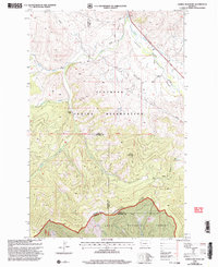
1999 Map of Saddle Mountain
USGS Topo · Published 2003About this map
The Flathead Indian Reservation dominates this mountainous landscape, where the Jocko River and Valley Creek carve through the steep terrain. This area, located at the juncture of Lake, Sanders, and Missoula counties, reflects a rugged geography of timbered slopes and remote water sources like Jocko Spring and Hewolf Creek. The northern portion of the Lolo National Forest reaches into the southern half of the sheet, centered on the prominent peak of Saddle Mountain. Settlement is sparse, with human activity primarily represented by the Nielson Ranch and small-scale resource extraction indicated by Prospects and a Mine. A network of simple travel ways, including Loop Road and various unnamed trails, suggests a landscape utilized for ranching, forestry, and traditional access rather than heavy development during the late twentieth century.
Find a feature on this map
27 named features on this map. Tap any name to fly to it.
Don’t see what you’re looking for? This feature index may not catch every label — zoom into the map to look around manually.
Map Details
Editions of this 1999 Saddle Mountain Map
This is the sole edition of this map. No revisions or reprints were ever made.
Other maps of this area

1956 · Wallace
USGS Topo · 1:250,000

1959 · Alberton
USGS Topo · 1:62,500

1959 · Arlee
USGS Topo · 1:62,500

1960 · Wallace
USGS Topo · 1:250,000

1964 · Dixon
USGS Topo · 1:24,000

1964 · Saint Ignatius
USGS Topo · 1:24,000

1964 · Ravalli
USGS Topo · 1:24,000
1984 · Arlee
USGS Topo · 1:24,000
1984 · Evaro
USGS Topo · 1:24,000
1984 · Huson
USGS Topo · 1:24,000