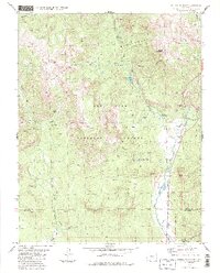
1984 Map of Saddle Mountain
USGS Topo · Published 1984About this map
The Weminuche Wilderness and San Juan National Forest dominate this high-elevation landscape along the border of Archuleta and Mineral Counties. This 1984 survey documents a region defined by the headwaters of the West Fork San Juan River and East Fork San Juan River. Local land use is characterized by outdoor recreation and early resource extraction, evidenced by the Rod and Gun Club Lake and the Blacks Mine.
Find a feature on this map
43 named features on this map. Tap any name to fly to it.
Don’t see what you’re looking for? This feature index may not catch every label — zoom into the map to look around manually.
Map Details
Editions of this 1984 Saddle Mountain Map
2 editions found
Other maps of this area

1905 · San Cristobal
USGS Topo · 1:125,000

1907 · San Cristobal
USGS Topo · 1:125,000

1913 · Summitville
USGS Topo · 1:125,000

1914 · Creede
USGS Topo · 1:125,000

1915 · Summitville
USGS Topo · 1:125,000

1916 · Creede
USGS Topo · 1:125,000

1924 · Pagosa Springs
USGS Topo · 1:125,000

1927 · Pagosa Springs
USGS Topo · 1:125,000

1945 · Durango
USGS Topo · 1:250,000

1953 · Durango
USGS Topo · 1:250,000