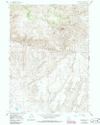
1959 Map of Saddle Rock
USGS Topo · Published 1985About this map
Rattlesnake Hills dominate the northern terrain of this Natrona County landscape, where the namesake Saddle Rock and Sagehen Hill provide prominent landmarks. The area is defined by a complex network of seasonal drainage systems, including Cottonwood Creek and Chokecherry Creek, which carve through the high plains. Human presence is concentrated at the Cottonwood Ranch, a lone settlement node in an otherwise open range managed through the mid-20th century.
Find a feature on this map
12 named features on this map. Tap any name to fly to it.
Don’t see what you’re looking for? This feature index may not catch every label — zoom into the map to look around manually.
Map Details
Editions of this 1959 Saddle Rock Map
3 editions found
Other maps of this area

1955 · Casper
USGS Topo · 1:250,000

1958 · Casper
USGS Topo · 1:250,000

1959 · Eightmile Draw
USGS Topo · 1:24,000

1959 · Horse Creek Springs
USGS Topo · 1:24,000

1959 · Sanford Ranch
USGS Topo · 1:24,000
1959 · Stinking Water Creek
USGS Topo · 1:24,000

1959 · Saddle Rock
USGS Topo · 1:24,000

1959 · Miller Spring
USGS Topo · 1:24,000

1959 · Barlow Gap
USGS Topo · 1:24,000
1959 · Garfield Peak
USGS Topo · 1:24,000