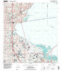
1998 Map of Safety Harbor
USGS Topo · Published 2001About this map
Old Tampa Bay dominates the eastern half of this coastal landscape, bridged by the Courtney Campbell Causeway which connects the growing communities of the Pinellas peninsula to the mainland. The area exhibits a dense suburban fabric in the late 1990s, characterized by residential developments such as Coachman, Dellwood, and Bayview that surround natural features like Alligator Lake and Cooper Bayou. Historical sites like the McMullen Cem and the expansive Sylvan Abbey Memorial Park Cemetery stand alongside modern infrastructure, including the Saint Petersburg-Clearwater International Airport. Industrial and utility land use is evident in the presence of the Sewage Disposal Plant and the specialized U.S. Res Pinellas Plant U.S. Dept of Energy in the south, while the shoreline is dotted with natural landmarks like Booth Point and Bunker Hill Island.
Find a feature on this map
48 named features on this map. Tap any name to fly to it.
Don’t see what you’re looking for? This feature index may not catch every label — zoom into the map to look around manually.
Map Details
Editions of this 1998 Safety Harbor Map
This is the sole edition of this map. No revisions or reprints were ever made.
Other maps of this area

1921 · Sand Key
USGS Topo · 1:62,500

1921 · St Petersburg
USGS Topo · 1:62,500

1943 · St Petersburg
USGS Topo · 1:31,680

1943 · Gandy Bridge
USGS Topo · 1:31,680

1943 · Bay Pines
USGS Topo · 1:31,680

1943 · Safety Harbor
USGS Topo · 1:31,680

1943 · Dunedin
USGS Topo · 1:31,680

1943 · Port Tampa
USGS Topo · 1:31,680

1943 · Clearwater
USGS Topo · 1:24,000

1943 · Oldsmar
USGS Topo · 1:24,000