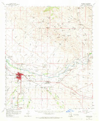
1960 Map of Safford
USGS Topo · Published 1966About this map
The Gila River valley serves as the central artery for this 1960s desert landscape, where irrigation canals like the San Jose Canal support agriculture against a backdrop of arid peaks. The city of Safford and neighboring Thatcher form the hub of Graham County, linked by the Southern Pacific railroad and the presence of the Safford Municipal Airport. To the north, the terrain climbs toward Weber Peak and Turtle Mountain, a region marked by mining activity at the Ben Hur Mine and Lone Star Mine.
Find a feature on this map
87 named features on this map. Tap any name to fly to it.
Don’t see what you’re looking for? This feature index may not catch every label — zoom into the map to look around manually.
Map Details
Editions of this 1960 Safford Map
3 editions found

Other maps of this area

1902 · Clifton
USGS Topo · 1:62,500

1913 · Morenci
USGS Topo · 1:125,000

1915 · Morenci
USGS Topo · 1:125,000

1942 · Mt. Graham
USGS Topo · 1:62,500

1945 · Mt. Graham
USGS Topo · 1:62,500

1954 · Silver City
USGS Topo · 1:250,000

1954 · Clifton
USGS Topo · 1:250,000

1957 · Clifton
USGS Topo · 1:250,000

1958 · Silver City
USGS Topo · 1:250,000

1958 · Clifton
USGS Topo · 1:250,000