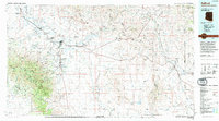
1994 Map of Safford
USGS Topo · Published 1994About this map
The Gila Valley serves as the agricultural and social spine of this region, where the Gila River supports a string of communities including Safford, Thatcher, and Pima. By the mid-1990s, the landscape reflects a complex geography of water management and high-altitude terrain, with the Pinaleno Mountains rising sharply to the southwest. The presence of Eastern Arizona College in Thatcher and the Safford Municipal Airport nearby indicates the area's role as a regional hub for education and transit.
Find a feature on this map
103 named features on this map. Tap any name to fly to it.
Don’t see what you’re looking for? This feature index may not catch every label — zoom into the map to look around manually.
Map Details
Editions of this 1994 Safford Map
2 editions found
Other maps of this area

1902 · Clifton
USGS Topo · 1:62,500

1910 · Mogollon
USGS Topo · 1:125,000

1912 · Mogollon
USGS Topo · 1:125,000

1913 · Morenci
USGS Topo · 1:125,000

1915 · Morenci
USGS Topo · 1:125,000

1917 · San Simon
USGS Topo · 1:125,000

1922 · Willcox
USGS Topo · 1:125,000

1926 · Orange Butte
USGS Topo · 1:62,500

1928 · Bowie
USGS Topo · 1:62,500

1940 · Sierra Bonita Ranch
USGS Topo · 1:62,500