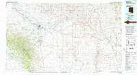
1994 Map of Safford
USGS Topo · Published 1994About this map
The Gila Valley serves as a vital agricultural corridor in this 1990s portrait of southeastern Arizona, defined by an intricate network of irrigation including the Graham Canal, Montezuma Canal, and Tidwell Canal. The hub of Safford and the campus of Eastern Arizona College in Thatcher anchor the settlement pattern along the Gila River, while smaller communities like Solomon and San Jose mark the transition toward the desert uplands. To the south, the massive Pinaleno Mountains rise sharply, dominated by peaks such as Graham Peak and Heliograph Peak within the Coronado National Forest. This era shows the region's balance between river-fed farming and the high-elevation wilderness of the Peloncillo Mountains near the New Mexico border, where the Southern Pacific RR cuts through the desert toward Duncan.
Find a feature on this map
109 named features on this map. Tap any name to fly to it.
Don’t see what you’re looking for? This feature index may not catch every label — zoom into the map to look around manually.
Map Details
Editions of this 1994 Safford Map
2 editions found
Other maps of this area

1902 · Clifton
USGS Topo · 1:62,500

1910 · Mogollon
USGS Topo · 1:125,000

1912 · Mogollon
USGS Topo · 1:125,000

1913 · Morenci
USGS Topo · 1:125,000

1915 · Morenci
USGS Topo · 1:125,000

1917 · San Simon
USGS Topo · 1:125,000

1922 · Willcox
USGS Topo · 1:125,000

1926 · Orange Butte
USGS Topo · 1:62,500

1928 · Bowie
USGS Topo · 1:62,500

1940 · Sierra Bonita Ranch
USGS Topo · 1:62,500