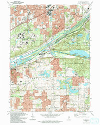
1993 Map of Sag Bridge
USGS Topo · Published 1993About this map
Industrial and natural corridors converge at Sag Bridge, where the Des Plaines River runs parallel to both the Illinois and Michigan Canal and the massive Chicago Sanitary and Ship Canal. This 1993 edition, based on earlier surveys and updated via aerial photography, details the complex land use at the intersection of Cook, Will, and DuPage counties. The landscape is dominated by the sprawling Waterfall Glen County Forest Preserve and the Argonne National Laboratory Reservation, which sit in contrast to the dense residential growth of Darien and Burr Ridge.
Find a feature on this map
72 named features on this map. Tap any name to fly to it.
Don’t see what you’re looking for? This feature index may not catch every label — zoom into the map to look around manually.
Map Details
Editions of this 1993 Sag Bridge Map
This is the sole edition of this map. No revisions or reprints were ever made.
Other maps of this area

1890 · Des Plaines
USGS Topo · 1:62,500

1891 · Riverside
USGS Topo · 1:62,500

1892 · Joliet
USGS Topo · 1:62,500

1893 · Riverside
USGS Topo · 1:62,500

1894 · Des Plaines
USGS Topo · 1:62,500

1900 · Des Plaines
USGS Topo · 1:62,500

1900 · Riverside
USGS Topo · 1:62,500

1901 · Des Plaines
USGS Topo · 1:62,500

1901 · Riverside
USGS Topo · 1:62,500

1908 · Wheaton
USGS Topo · 1:62,500