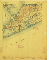
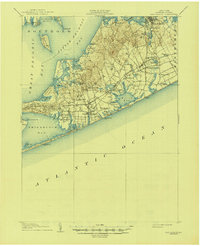
1904 Map of Sag Harbor
USGS Topo · Published 1909About this map
The Shinnecock Indian Reservation occupies a prominent peninsula on this 1903 survey, positioned between the Shinnecock Hills and the open water. The landscape of the South Fork is defined by a dense network of coastal ponds and creeks, such as Agawam Lake, Old Town Pond, and Scallop Pond, which shaped the early development of Southampton and Bridgehampton. Inland, the terrain rises toward Scuttlehole and Deerfield, while the northern coastline is punctuated by small harbors like North Sea Harbor and Cutchogue Harbor.
Find a feature on this map
88 named features on this map. Tap any name to fly to it.
Don’t see what you’re looking for? This feature index may not catch every label — zoom into the map to look around manually.
Map Details
Editions of this 1904 Sag Harbor Map
6 editions found
Other maps of this area

1903 · Sag Harbor
USGS Topo · 1:62,500

1903 · Gardiners Island
USGS Topo · 1:62,500

1903 · Riverhead
USGS Topo · 1:62,500

1904 · Sag Harbor
USGS Topo · 1:62,500

1904 · Shelter Island
USGS Topo · 1:62,500

1904 · Easthampton
USGS Topo · 1:62,500

1904 · Gardiners Island
USGS Topo · 1:62,500

1904 · Riverhead
USGS Topo · 1:62,500

1921 · Gardiners Island
USGS Topo · 1:62,500

1921 · Easthampton
USGS Topo · 1:62,500