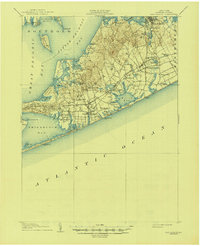
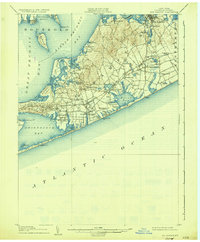
1904 Map of Sag Harbor
USGS Topo · Published 1944About this map
Sag Harbor serves as a major hub on the South Fork at the turn of the century, positioned where the Montauk Division of the Long Island R. R. reaches the edge of Little Peconic Bay. The landscape is a complex network of coastal necks and ponds, notably Cow Neck and Sebonac Neck, which define the fragmented shoreline. The presence of the Shinnecock Indian Reservation and various Life Saving Stations like Shinnecock L.S.S. and Southampton L.S.S. reflect the historical importance of both ancestral lands and maritime safety along the Atlantic coast. Inland, established hamlets such as Bridgehampton and Water Mill are connected by the Division Line, showing an organized transition from the agrarian interiors to the bustling seaside communities of Southampton and New Suffolk.
Find a feature on this map
83 named features on this map. Tap any name to fly to it.
Don’t see what you’re looking for? This feature index may not catch every label — zoom into the map to look around manually.
Map Details
Editions of this 1904 Sag Harbor Map
6 editions found
Other maps of this area

1903 · Sag Harbor
USGS Topo · 1:62,500

1903 · Gardiners Island
USGS Topo · 1:62,500

1903 · Riverhead
USGS Topo · 1:62,500

1904 · Sag Harbor
USGS Topo · 1:62,500

1904 · Shelter Island
USGS Topo · 1:62,500

1904 · Easthampton
USGS Topo · 1:62,500

1904 · Gardiners Island
USGS Topo · 1:62,500

1904 · Riverhead
USGS Topo · 1:62,500

1921 · Gardiners Island
USGS Topo · 1:62,500

1921 · Easthampton
USGS Topo · 1:62,500