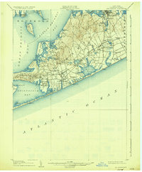
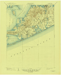
1904 Map of Sag Harbor
USGS Topo · Published 1935About this map
Sag Harbor and the surrounding townships of Southampton and Easthampton are captured here at the beginning of the twentieth century. The map illustrates a landscape defined by its maritime geography, with Life Saving Stations like Shinnecock L.S.S. and Mecox L.S.S. positioned along the Atlantic coastline. The coastal economy and transportation network are evident in the path of the Long Island R. R. and its Montauk Division, which connect inland settlements such as Bridgehampton and Water Mill. The inland terrain is marked by numerous small bodies of water like Kellis Pond and Poxabogue Pond, while the Shinnecock Indian Reservation occupies a prominent peninsula between Shinnecock Bay and the Atlantic. This survey offers a clear view of the area's transition from a collection of isolated whaling and farming villages into a more integrated coastal region served by rail, specifically showing the early rail infrastructure at Wainscott Sta. and Hampton Park.
Find a feature on this map
75 named features on this map. Tap any name to fly to it.
Don’t see what you’re looking for? This feature index may not catch every label — zoom into the map to look around manually.
Map Details
Editions of this 1904 Sag Harbor Map
6 editions found
Other maps of this area

1903 · Sag Harbor
USGS Topo · 1:62,500

1903 · Gardiners Island
USGS Topo · 1:62,500

1903 · Riverhead
USGS Topo · 1:62,500

1904 · Sag Harbor
USGS Topo · 1:62,500

1904 · Shelter Island
USGS Topo · 1:62,500

1904 · Easthampton
USGS Topo · 1:62,500

1904 · Gardiners Island
USGS Topo · 1:62,500

1904 · Riverhead
USGS Topo · 1:62,500

1921 · Gardiners Island
USGS Topo · 1:62,500

1921 · Easthampton
USGS Topo · 1:62,500