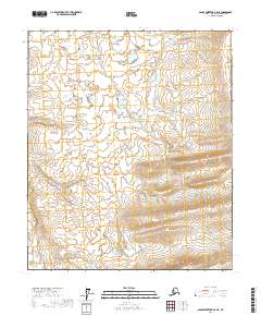
2017 Map of Sagavanirktok A-5 NE
USGS Topo · Published 2017About this map
Township and range lines define the structure of this North Slope landscape, where the T3s R10e and T3s R11e boundaries intersect an area characterized by subtle topographic shifts and scattered wetlands. The map provides a detailed survey of the Public Land Survey System (PLSS) layout in this portion of Alaska, documenting the grid that organizes the territory. Without the presence of established roads or named settlements, the geographic focus remains entirely on the physical landform and the administrative divisions of T2s R10e and T4s R11e. This survey serves as a fundamental record of the undeveloped interior, illustrating how the remote northern terrain was systematically charted into square-mile sections by the U.S. Geological Survey and the BLM.
Find a feature on this map
6 named features on this map. Tap any name to fly to it.
Don’t see what you’re looking for? This feature index may not catch every label — zoom into the map to look around manually.
Map Details
Editions of this 2017 Sagavanirktok A-5 NE Map
This is the sole edition of this map. No revisions or reprints were ever made.
Other maps of this area

1951 · Sagavanirktok D-5
USGS Topo · 1:250,000

1956 · Sagavanirktok
USGS Topo · 1:250,000

1958 · Sagavanirktok
USGS Topo · 1:250,000

1964 · Sagavanirktok
USGS Topo · 1:250,000
1971 · Sagavanirktok B-4
USGS Topo · 1:63,360
1971 · Sagavanirktok A-5
USGS Topo · 1:63,360
1971 · Sagavanirktok B-5
USGS Topo · 1:63,360
1971 · Sagavanirktok A-4
USGS Topo · 1:63,360
2017 · Sagavanirktok B-4 SW
USGS Topo · 1:25,000
2017 · Sagavanirktok A-5 NW
USGS Topo · 1:25,000