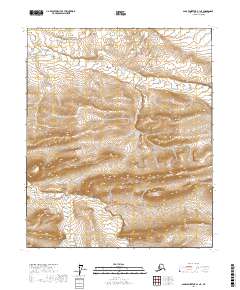
2017 Map of Sagavanirktok B-1 NE
USGS Topo · Published 2017About this map
Shaviovik River flows through this remote stretch of the North Slope, where the drainage patterns of the Alaskan tundra are recorded with high-resolution precision. The landscape is defined by the winding paths of Kemik Cr and Fin Cr, which carve through the topographic relief of the Brooks Range foothills. This 2017 study captures the complex hydrological network of the region, including Juniper Cr at the northern edge. The absence of roads or permanent settlements emphasizes the wilderness character of the terrain, making this a vital resource for understanding the natural geography of the Arctic before any modern industrial footprint. Public Land Survey System township and range lines, such as t1n r21e and t2n r20e, provide the only man-made coordinate system over this otherwise undisturbed environment.
Find a feature on this map
10 named features on this map. Tap any name to fly to it.
Don’t see what you’re looking for? This feature index may not catch every label — zoom into the map to look around manually.
Map Details
Editions of this 2017 Sagavanirktok B-1 NE Map
This is the sole edition of this map. No revisions or reprints were ever made.
Other maps of this area

1951 · Sagavanirktok D-5
USGS Topo · 1:250,000

1951 · Mt. Michelson
USGS Topo · 1:250,000

1955 · Mount Michelson C-5
USGS Topo · 1:63,360
1955 · Sagavanirktok C-1
USGS Topo · 1:63,360

1956 · Mt. Michelson
USGS Topo · 1:250,000

1956 · Sagavanirktok
USGS Topo · 1:250,000

1958 · Sagavanirktok
USGS Topo · 1:250,000

1964 · Sagavanirktok
USGS Topo · 1:250,000
1971 · Sagavanirktok B-1
USGS Topo · 1:63,360
1971 · Mount Michelson B-5
USGS Topo · 1:63,360