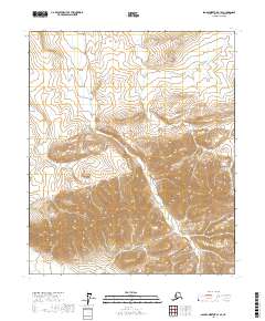
2017 Map of Sagavanirktok B-1 SE
USGS Topo · Published 2017About this map
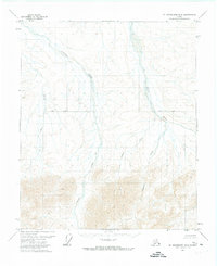
Shaviovik River winds through the high-elevation landscape of the North Slope in this 2017 topographic survey. The terrain is defined by a dense network of drainages and steep contour gradients that illustrate the complex hydrology of the Arctic coastal plain's interior. In the southeastern portion of the map, Fin Cr and the headwaters of the Echooka River emerge from the steep ridges, while Kemik Cr flows through the central valleys. This map provides a detailed record of the natural drainage patterns and landforms within the Arctic National Wildlife Refuge area, capturing the untouched wilderness before any significant modern infrastructure or settlement reached these remote townships.
Find a feature on this map
8 named features on this map. Tap any name to fly to it.
Don’t see what you’re looking for? This feature index may not catch every label — zoom into the map to look around manually.
Map Details
Editions of this 2017 Sagavanirktok B-1 SE Map
This is the sole edition of this map. No revisions or reprints were ever made.
Other maps of this area

1951 · Sagavanirktok D-5
USGS Topo · 1:250,000

1951 · Mt. Michelson
USGS Topo · 1:250,000

1956 · Mt. Michelson
USGS Topo · 1:250,000

1956 · Sagavanirktok
USGS Topo · 1:250,000

1958 · Sagavanirktok
USGS Topo · 1:250,000

1964 · Sagavanirktok
USGS Topo · 1:250,000
1971 · Sagavanirktok A-1
USGS Topo · 1:63,360
1971 · Sagavanirktok B-1
USGS Topo · 1:63,360
1971 · Mount Michelson A-5
USGS Topo · 1:63,360
1971 · Mount Michelson B-5
USGS Topo · 1:63,360