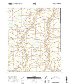
2017 Map of Sagavanirktok C-3 NE
USGS Topo · Published 2017About this map
Hydrological patterns and remote Arctic wetlands dominate this North Slope landscape, as documented by the U.S. Geological Survey in the early 21st century. The terrain is defined by an intricate network of lakes, ponds, and braided watercourses that shift through the permafrost-underlain tundra. Organized by the Public Land Survey System, the map covers portions of T5n R15e, T5n R16e, T4n R15e, T4n R16e, T3n R15e, and T3n R16e. This survey provides a baseline of the regional hydrography, showing the distribution of standing water across the low-relief coastal plain. The absence of named settlements or infrastructure highlights the isolation of this borough, where the land remains shaped almost entirely by natural cycles and geological processes within the Sagavanirktok drainage system.
Find a feature on this map
6 named features on this map. Tap any name to fly to it.
Don’t see what you’re looking for? This feature index may not catch every label — zoom into the map to look around manually.
Map Details
Editions of this 2017 Sagavanirktok C-3 NE Map
This is the sole edition of this map. No revisions or reprints were ever made.
Other maps of this area

1951 · Sagavanirktok D-5
USGS Topo · 1:250,000

1955 · Sagavanirktok D-3
USGS Topo · 1:63,360
1955 · Sagavanirktok D-2
USGS Topo · 1:63,360

1956 · Sagavanirktok
USGS Topo · 1:250,000

1958 · Sagavanirktok
USGS Topo · 1:250,000

1964 · Sagavanirktok
USGS Topo · 1:250,000
1971 · Sagavanirktok C-2
USGS Topo · 1:63,360
1971 · Sagavanirktok C-3
USGS Topo · 1:63,360
2017 · Sagavanirktok D-3 SW
USGS Topo · 1:25,000
2017 · Sagavanirktok C-3 SE
USGS Topo · 1:25,000