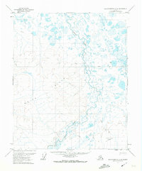
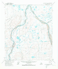
1971 Map of Sagavanirktok C-4
USGS Topo · Published 1974About this map
White Hills dominates the central terrain of this North Slope landscape, rising above the complex drainage patterns of the Toolik River. The map, based on aerial photography from 1970, depicts a remote wilderness defined by seasonal infrastructure rather than permanent settlements. Transport through this arctic environment relied heavily on the Winter Trail, which cuts across the tundra and marshes to connect isolated points. The presence of a Landing Strip and multiple Drill Holes points to early industrial exploration and resource survey efforts in the region. Small elevation markers or localized terrain features carry personal names like Clara and Susie, providing unique landmarks in an otherwise repeating landscape of ponds and streams. This survey provides a baseline of the regional topography before significant modern development altered the North Slope's accessibility.
Find a feature on this map
8 named features on this map. Tap any name to fly to it.
Don’t see what you’re looking for? This feature index may not catch every label — zoom into the map to look around manually.
Map Details
Editions of this 1971 Sagavanirktok C-4 Map
This is the sole edition of this map. No revisions or reprints were ever made.
Other maps of this area

1951 · Sagavanirktok D-5
USGS Topo · 1:250,000

1955 · Sagavanirktok D-3
USGS Topo · 1:63,360
1955 · Sagavanirktok D-5
USGS Topo · 1:63,360

1955 · Sagavanirktok D-4
USGS Topo · 1:63,360

1956 · Sagavanirktok
USGS Topo · 1:250,000

1958 · Sagavanirktok
USGS Topo · 1:250,000

1964 · Sagavanirktok
USGS Topo · 1:250,000
1971 · Sagavanirktok B-4
USGS Topo · 1:63,360
1971 · Sagavanirktok C-3
USGS Topo · 1:63,360
1971 · Sagavanirktok B-3
USGS Topo · 1:63,360