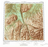
1958 Map of Sagavanirktok
USGS Topo · Published 1978About this map
Sagavanirktok River dominates this mid-1970s revision, serving as the central corridor for the Pipeline (Under construction) during its critical development phase. The landscape transition from the coastal plain to the northern foothills is marked by the distinctive White Hills and the prominent heights of Franklin Bluffs. Along this industrial lifeline, isolated outposts like Sagwon and Happy Valley appear alongside aviation infrastructure including a Landing strip. This survey captures the remote northern wilderness at the height of the energy boom, documenting early extraction efforts evidenced by an Oil well and seasonal access routes such as the Winter Trail. Numerous watercourses, including the Ivishak River and Kuparuk River, weave through a terrain dotted with pingos and survey benchmarks, providing a detailed look at the hydrology of the North Slope.
Find a feature on this map
58 named features on this map. Tap any name to fly to it.
Don’t see what you’re looking for? This feature index may not catch every label — zoom into the map to look around manually.
Map Details
Editions of this 1958 Sagavanirktok Map
4 editions found

Other maps of this area

1951 · Harrison Bay
USGS Topo · 1:250,000

1951 · Beechey Point
USGS Topo · 1:250,000

1951 · Sagavanirktok D-5
USGS Topo · 1:250,000

1951 · Chandler Lake
USGS Topo · 1:250,000

1951 · Brooks
USGS Topo · 1:250,000

1951 · Arctic
USGS Topo · 1:250,000

1951 · Mt. Michelson
USGS Topo · 1:250,000

1952 · Umiat
USGS Topo · 1:250,000

1955 · Flaxman Island
USGS Topo · 1:250,000

1955 · Harrison Bay
USGS Topo · 1:250,000