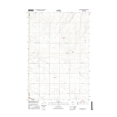
2017 Map of Sagebrush Ridge
USGS Topo · Published 2017About this map
Sagebrush Ridge dominates the terrain of this Yakima and Benton County borderland, where the high desert landscape is punctuated by The Gap, a prominent pass in the ridgeline. This 2017 survey shows a methodical grid of rural roads, including Snipes Rd and N Hinzerling Rd, that navigate the varying elevations between the ridge and the lower-lying areas. The presence of Spring Cr provides a glimpse into the intermittent drainage patterns of the region. The road network, with names like N Missimer Rd and N Gap Rd, suggests a landscape organized for agricultural or utility access, typical of the central Washington interior. Boundary lines for Yakima Co and Benton Co cut through the survey, marking the administrative divisions that govern these high-elevation slopes and the valleys below.
Find a feature on this map
24 named features on this map. Tap any name to fly to it.
Don’t see what you’re looking for? This feature index may not catch every label — zoom into the map to look around manually.
Map Details
Editions of this 2017 Sagebrush Ridge Map
This is the sole edition of this map. No revisions or reprints were ever made.
Other maps of this area

1915 · Prosser
USGS Topo · 1:125,000

1917 · Prosser
USGS Topo · 1:125,000

1950 · Grandview
USGS Topo · 1:62,500

1951 · Grandview
USGS Topo · 1:62,500

1951 · Corral Canyon
USGS Topo · 1:62,500

1953 · Walla Walla
USGS Topo · 1:250,000

1958 · Walla Walla
USGS Topo · 1:250,000

1965 · Whitstran
USGS Topo · 1:62,500
1965 · Prosser
USGS Topo · 1:62,500
1965 · Prosser
USGS Topo · 1:24,000