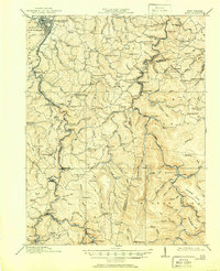
1914 Map of Sago
USGS Topo · Published 1950About this map
Buckhannon anchors the northwest corner of this West Virginia landscape, where the Pickens Br line of the Baltimore and Ohio RR follows the winding course of the Buckhannon River southward. The terrain is marked by a dense network of mountain hollows and ridges, supporting a surprisingly high concentration of local institutions, including the Indian Camp School, Sunny Point School, and Hanging Run School. Small settlements like Sago, Tallmansville, and Alexander serve as focal points for rural life before the heavy industrialization of the later 20th century.
Find a feature on this map
139 named features on this map. Tap any name to fly to it.
Don’t see what you’re looking for? This feature index may not catch every label — zoom into the map to look around manually.
Map Details
Editions of this 1914 Sago Map
4 editions found

Other maps of this area

1886 · St. George
USGS Topo · 1:125,000

1889 · Beverly
USGS Topo · 1:125,000

1891 · St. George
USGS Topo · 1:125,000

1892 · Beverly
USGS Topo · 1:125,000

1893 · Buckhannon
USGS Topo · 1:125,000

1896 · Buckhannon
USGS Topo · 1:125,000

1897 · Buckhannon
USGS Topo · 1:125,000

1904 · Philippi
USGS Topo · 1:62,500

1904 · Weston
USGS Topo · 1:62,500

1907 · Belington
USGS Topo · 1:62,500