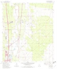
1981 Map of Sahuarita
USGS Topo · Published 1982About this map
The Santa Cruz Valley defines this portion of Pima County, showing a landscape shaped by industrial mining, military operations, and rapid residential growth in the early 1980s. The Southern Pacific railroad corridor anchors the valley floor, connecting the settlement of Sahuarita and the developing community of Green Valley to the south. Significant land use patterns are visible through the presence of the Sahuarita Air Force Range to the east and the sprawling Santa Rita Experimental Range and Wildlife Area. The infrastructure of the local economy is clearly marked by features such as the Duval Mine Road and several large Tailings Ponds and Gravel Pits, which indicate the region's copper and mineral extraction history. Educational and civic growth is evidenced by the Sahuarita High Sch and Anamax Park, providing a detailed record of the area's transition into a modern suburban hub.
Find a feature on this map
33 named features on this map. Tap any name to fly to it.
Don’t see what you’re looking for? This feature index may not catch every label — zoom into the map to look around manually.
Map Details
Editions of this 1981 Sahuarita Map
2 editions found
Other maps of this area

1904 · Patagonia
USGS Topo · 1:125,000

1904 · Tucson
USGS Topo · 1:125,000

1905 · Patagonia
USGS Topo · 1:125,000

1905 · Tucson
USGS Topo · 1:125,000

1920 · Arivaca
USGS Topo · 1:125,000

1925 · Samaniego Peak
USGS Topo · 1:62,500

1925 · San Xavier
USGS Topo · 1:62,500

1926 · Helvetia
USGS Topo · 1:62,500

1934 · Tucson Mountains
USGS Topo · 1:125,000

1939 · Twin Buttes
USGS Topo · 1:62,500