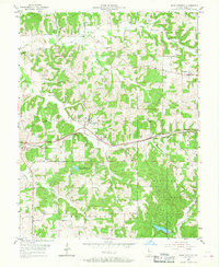
1955 Map of Saint Anthony
USGS Topo · Published 1967About this map
Saint Anthony serves as a central hub in this southern Indiana landscape, which transitions from agricultural tracts in the north to the dense woodlands of the Ferdinand State Forest in the south. The Southern railroad line cuts an east-west path through the territory, connecting the small settlements of Bretzville, Saint Marks, and Kyana. Waterways like Flat Creek and Hall Creek define the drainage patterns of the region, while the Saint Anthony Conservation Lake provides a notable local landmark. For those researching local heritage, the map identifies several smaller burial sites including Cox Cem, Dugan Cem, and Bretzville Cem. The presence of the Lookout Tower and the Fish Hatchery near the forest boundary highlights the area's mid-century role in conservation and resource management.
Find a feature on this map
26 named features on this map. Tap any name to fly to it.
Don’t see what you’re looking for? This feature index may not catch every label — zoom into the map to look around manually.
Map Details
Editions of this 1955 Saint Anthony Map
2 editions found
Other maps of this area

1900 · St Meinrad
USGS Topo · 1:62,500

1903 · St. Meinrad
USGS Topo · 1:62,500

1946 · Jasper
USGS Topo · 1:24,000

1954 · Dubois
USGS Topo · 1:24,000

1954 · Huntingburg
USGS Topo · 1:24,000

1955 · Saint Anthony
USGS Topo · 1:24,000

1956 · Vincennes
USGS Topo · 1:250,000

1957 · Vincennes
USGS Topo · 1:250,000

1957 · Cuzco
USGS Topo · 1:24,000

1957 · Birdseye
USGS Topo · 1:24,000