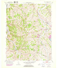
1953 Map of Saint Catharine
USGS Topo · Published 1979About this map
Cartwright Creek meanders through this portion of central Kentucky, anchoring a landscape shaped by religious and educational institutions in the mid-20th century. The prominent Saint Catharine Academy and Saint Catharine PO stand as central landmarks, reflecting the local importance of the Dominican sisters in Washington County. Nearby, the St Rose Priory further illustrates the deep-rooted Catholic heritage of the region.
Find a feature on this map
28 named features on this map. Tap any name to fly to it.
Don’t see what you’re looking for? This feature index may not catch every label — zoom into the map to look around manually.
Map Details
Editions of this 1953 Saint Catharine Map
2 editions found
Other maps of this area

1953 · Loretto
USGS Topo · 1:24,000

1953 · Brush Grove
USGS Topo · 1:24,000

1953 · Maud
USGS Topo · 1:24,000

1953 · Saint Catharine
USGS Topo · 1:24,000

1953 · Lebanon East
USGS Topo · 1:24,000

1953 · Bardstown
USGS Topo · 1:24,000

1953 · Springfield
USGS Topo · 1:24,000

1953 · Raywick
USGS Topo · 1:24,000

1953 · Lebanon West
USGS Topo · 1:24,000

1957 · Winchester
USGS Topo · 1:250,000