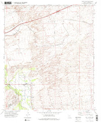
1973 Map of Saint David
USGS Topo · Published 1976About this map
The San Pedro River corridor defines the western edge of this 1970s survey, where irrigation and transport infrastructure converge near the settlement of Saint David. This area of the San Pedro Valley is characterized by the Saint David Ditch and its proximity to the Southern Pacific railroad line, which skirts the valley floor. Moving eastward, the terrain transitions into the wide, arid expanse of Lonesome Valley, marked by ephemeral watercourses like Dragoon Wash and Sheep Wash. Several small stops and sidings along the rail and road network, including Sibyl, Fenner, and Adamson, illustrate the rural settlement patterns before later regional development. Local civic life is anchored by the High Sch in Saint David, while industrial activity is noted by a Substation and several Borrow Pit locations near the Sibyl Interchange.
Find a feature on this map
23 named features on this map. Tap any name to fly to it.
Don’t see what you’re looking for? This feature index may not catch every label — zoom into the map to look around manually.
Map Details
Editions of this 1973 Saint David Map
2 editions found
Other maps of this area

1915 · Benson
USGS Topo · 1:125,000

1922 · St. David
USGS Topo · 1:62,500

1926 · Whetstone
USGS Topo · 1:62,500

1943 · Benson
USGS Topo · 1:125,000

1943 · Dragoon
USGS Topo · 1:62,500

1945 · Happy Valley
USGS Topo · 1:62,500

1956 · Nogales
USGS Topo · 1:250,000

1956 · Tucson
USGS Topo · 1:250,000

1958 · Nogales
USGS Topo · 1:250,000

1958 · Tucson
USGS Topo · 1:250,000