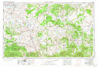
1954 Map of Saint Johns
USGS Topo · Published 1973About this map
Saint Johns serves as a central hub in this mid-century survey of the high desert and mountain borderlands between Arizona and New Mexico. The landscape transitions from the striking geological formations of Petrified Forest National Park, featuring landmarks like Agate House and Long Logs, to the dense timber of the Apache National Forest. The Little Colorado River and Zuni River systems define the drainage of the region, supporting early settlements and reservoirs such as Lyman Reservoir and Concho Lake.
Find a feature on this map
109 named features on this map. Tap any name to fly to it.
Don’t see what you’re looking for? This feature index may not catch every label — zoom into the map to look around manually.
Map Details
Editions of this 1954 Saint Johns Map
3 editions found

Other maps of this area

1883 · Mt. Taylor
USGS Topo · 1:250,000

1883 · Tusayan
USGS Topo · 1:250,000

1886 · St Johns
USGS Topo · 1:250,000

1886 · Wingate
USGS Topo · 1:250,000

1886 · Mt. Taylor
USGS Topo · 1:250,000

1886 · Tusayan
USGS Topo · 1:250,000

1886 · Fort Defiance
USGS Topo · 1:250,000

1886 · Holbrook
USGS Topo · 1:250,000

1892 · Fort Defiance
USGS Topo · 1:250,000

1892 · St Johns
USGS Topo · 1:250,000