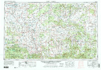
1954 Map of Saint Johns
USGS Topo · Published 1991About this map
The Mogollon Rim and White Mountains dominate this 1954 landscape, where high-country forests meet the high desert plateaus of the Arizona-New Mexico borderlands. Agricultural and ranching life centers on the Little Colorado River valley, supporting settlements like Saint Johns and Springerville-Eagar. The map records a transition in land use, showing the expansion of Petrified Forest National Park and the reliance on water management through features like the Lyman Reservoir and Concho Lake. Extensive tribal lands, including the Zuni Indian Reservation and Fort Apache Indian Reservation, illustrate the long-standing cultural geography of the region. Transportation follows historic corridors, with U.S. 60 and the Atchison Topeka and Santa Fe RR providing vital links through the high desert, while landmarks like The Teepees and Agate House mark the unique geology of the Painted Desert area.
Find a feature on this map
89 named features on this map. Tap any name to fly to it.
Don’t see what you’re looking for? This feature index may not catch every label — zoom into the map to look around manually.
Map Details
Editions of this 1954 Saint Johns Map
3 editions found

Other maps of this area

1883 · Mt. Taylor
USGS Topo · 1:250,000

1883 · Tusayan
USGS Topo · 1:250,000

1886 · St Johns
USGS Topo · 1:250,000

1886 · Wingate
USGS Topo · 1:250,000

1886 · Mt. Taylor
USGS Topo · 1:250,000

1886 · Tusayan
USGS Topo · 1:250,000

1886 · Fort Defiance
USGS Topo · 1:250,000

1886 · Holbrook
USGS Topo · 1:250,000

1892 · Fort Defiance
USGS Topo · 1:250,000

1892 · St Johns
USGS Topo · 1:250,000