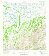
1952 Map of Saint Michael A-1
USGS Topo · Published 1963About this map
Meandering waterways dominate this 1950s survey of the Yukon-Kuskokwim Delta region, illustrating a landscape defined by complex drainage patterns and tundra. The Pikmiktalik River and Kogok River carve deep into the western and northern terrain, while the Nunavulnuk River provides a central corridor through the lower elevations. The topographic detail captures the subtle transition from the saturated lowlands to the rising elevations of the interior. In the eastern and southern portions of the quadrangle, the Mountain River and the headwaters of the Andreafsky River show the beginning of more defined upland relief. With no roads or settlements indicated, the map serves as a primary record of the natural hydrology and undeveloped wildlands as they were documented shortly after the mid-century.
Find a feature on this map
6 named features on this map. Tap any name to fly to it.
Don’t see what you’re looking for? This feature index may not catch every label — zoom into the map to look around manually.
Map Details
Editions of this 1952 Saint Michael A-1 Map
2 editions found
Other maps of this area

1951 · Unalakleet
USGS Topo · 1:250,000

1951 · St Michael
USGS Topo · 1:250,000

1951 · Holy Cross
USGS Topo · 1:250,000

1952 · Kwiguk
USGS Topo · 1:250,000

1952 · Kwiguk D-1
USGS Topo · 1:63,360
1952 · Saint Michael B-2
USGS Topo · 1:63,360

1952 · Saint Michael B-1
USGS Topo · 1:63,360

1952 · Kwiguk D-2
USGS Topo · 1:63,360

1952 · Saint Michael A-1
USGS Topo · 1:63,360

1952 · Saint Michael A-2
USGS Topo · 1:63,360