
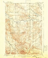
1905 Map of Saint Onge
USGS Topo · Published 1905About this map
Saint Onge and the small settlement of Snoma anchor this 1905 landscape where the Belle Fourche River winds across the northern plains. This survey, conducted by W. H. Herron and A. F. Dunnington, details the critical water and transport infrastructure of the early 1900s, notably the Chicago and Northwestern Ry cutting through the southwestern corner and the extensive Redwater Ditch system.
Find a feature on this map
27 named features on this map. Tap any name to fly to it.
Don’t see what you’re looking for? This feature index may not catch every label — zoom into the map to look around manually.
Map Details
Editions of this 1905 Saint Onge Map
2 editions found
Other maps of this area

1893 · Rapid
USGS Topo · 1:125,000

1894 · Deadwood
USGS Topo · 1:125,000

1898 · Rapid
USGS Topo · 1:125,000

1899 · Sturgis
USGS Topo · 1:62,500

1900 · Spearfish
USGS Topo · 1:62,500

1901 · Deadwood
USGS Topo · 1:125,000

1903 · Rapid
USGS Topo · 1:125,000

1905 · Indian
USGS Topo · 1:62,500

1906 · Two Top
USGS Topo · 1:62,500

1906 · Vale
USGS Topo · 1:62,500