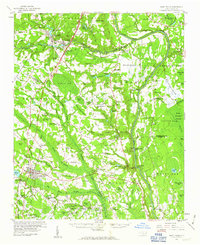
1959 Map of Saint Pauls
USGS Topo · Published 1961About this map
Saint Pauls stands as a hub of activity in this 1950s landscape, where the Virginia and Southern and Atlantic Coast Line railroads intersect. The map documents a rural corridor transitioning between the growing Fayetteville Municipal Airport in the north and the timber-and-water networks of the south. The winding course of the Cape Fear River serves as a major geographical boundary, marked by historic river access points like Tolar Landing and Prospect Hall Landing.
Find a feature on this map
118 named features on this map. Tap any name to fly to it.
Don’t see what you’re looking for? This feature index may not catch every label — zoom into the map to look around manually.
Map Details
Editions of this 1959 Saint Pauls Map
2 editions found

Other maps of this area

1948 · Fayetteville
USGS Topo · 1:62,500

1948 · Clifdale
USGS Topo · 1:62,500

1948 · Clifdale
USGS Topo · 1:24,000

1949 · Vander
USGS Topo · 1:24,000

1950 · Clifdale
USGS Topo · 1:24,000

1950 · Fayetteville
USGS Topo · 1:24,000

1951 · Clifdale
USGS Topo · 1:62,500

1953 · Florence
USGS Topo · 1:250,000

1953 · Raleigh
USGS Topo · 1:250,000

1954 · Florence
USGS Topo · 1:250,000